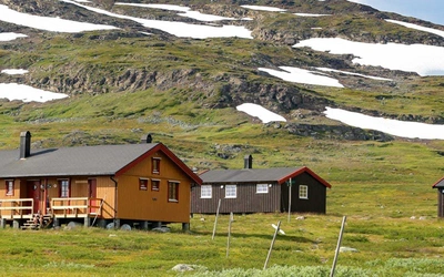
Five of the best walks and treks in Iceland
Iceland’s dramatic landscapes are a haven for walkers and trekkers, offering everything from glacier-capped volcanoes to steaming geothermal valleys. Whether you’re seeking a challenging multi-day trek or a scenic day hike, the Land of Ice and Fire delivers unforgettable experiences. Here are five of the best walks and treks in Iceland, showcasing the country’s extraordinary natural beauty and diversity.
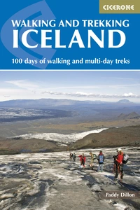
Walking and Trekking in Iceland
100 days of walking and multi-day treks
£17.95
This guidebook to walking routes in Iceland offers 49 day walks and 10 multi-stage treks including the classic Laugavegur Trail. The total of 100 days of routes described cater for most abilities, from waymarked walks to challenging glacier crossings. Information on public transport, accommodation, facilities and budget travel tips also included.
More information
Sandfell and Hvannadalshnúkur
What: Hvannadalshnúkur – Iceland's highest mountain
Start/finish: Sandfell, near Skaftafell
Distance: 23km (14¼ miles)
Total ascent/descent: 2000m (6560ft)
Time: 12hrs
Terrain: Steep, stony slopes, followed by glaciers. Start before 5am to avoid too much walking on soft, wet snow in the afternoon.
The hike to Hvannadalshnúkur begins at Sandfell, where a car park, ruined farm, and graveyard mark the starting point. From here, follow a rugged track to a path that crosses streams and zigzags up loose gravel slopes, passing a slender waterfall. The path continues towards a cairn at the edge of a bouldery slope, where the summit is briefly visible before being obscured. As the trail approaches the glacier at around 1000m, climbers should rope up for safety. The glacier’s icy surface is often unstable, with varying crevasses, so it’s essential to stay alert and retrace steps carefully.
The ascent to the summit of Hvannadalshnúkur, which stands at around 2110m, offers panoramic views of the Vatnajökull mountains and the coast. If the sub-glacial volcano of Grímsvötn is active, parts of the ice may appear blackened. As climbers reach around 1850m, the slope flattens, revealing the large crater of Öræfajökull. The final stretch of the climb involves navigating crevasses and a challenging ice-fall before reaching the summit. The summit dome can vary in height due to accumulated snow and ice, and careful attention to the terrain is essential throughout the climb. After reaching the summit, retrace your steps back to Sandfell.

Reykjavík and Seltjarnarnes
What: a pleasant coastal walk
Start/finish: Ráðhús (parliament) in Reykjavík
Distance: 20km (12½ miles)
Total ascent/descent: 100m (330ft)
Time: 5hrs
Terrain: Easy, low-level tarmac and gravel coastal paths, with some roads
This route begins in central Reykjavík at the Ráðhús, or parliament building, and leads towards the harbour, passing whale-watching kiosks and the Víkin Maritime Museum. Walking along coastal roads and footpaths, you'll enjoy scenic views of distant mountains like Snæfellsnes, Akrafjall, and Esja, before reaching the lighthouse at Grótta, located on a small island. Access to the island is restricted during the bird breeding season, but after that, it’s open for visits. The path continues beside Bakkatjörn, a tarn, before winding through coastal areas near a golf course and small harbours.
Further along the route, you'll pass Reykjavík airport, with expansive views towards the surrounding landscapes, including Vífilsfell and Keflavik. The path leads to Nauthólsvík geothermal beach, then uphill towards Perlan, a striking glass dome perched atop a hill. After exploring Perlan and its attractions, including a garden and ice cave, the route descends through a forested area, heading back toward the city centre. The final leg of the walk leads past BSÍ bus station and through the peaceful Hljómskalagarður park, returning to the heart of Reykjavík.

Hellismannaleið, Laugavegur and Skógar Trail
What: the most popular long-distance trek in Iceland
Start: Rjúpnavellir
Finish: Skógar
Distance: 143km (88½ miles) – Hellismannaleið 59km (36 miles); Laugavegur 55km (34½ miles); Skógar Trail 29km (18 miles)
Time: 9 days
Terrain: Easy at first on the Hellismannaleið, but hilly later. High and exposed on the Laugavegur, with some steep and stony slopes. Gentler later, but with increasingly difficult river crossings. A steep, rocky ascent on the Skógar Trail, with permanent ice on its high and exposed top. A long and gentle descent to Skógar.
Facilities: Huts. Small shops at Landmannalaugar and Langidalur, with basic food supplies available along the Laugavegur. Restaurant at Húsadalur. Shop, restaurant, hostel and hotels at Skógar.
Accommodation: Huts and/or camping throughout, though camping is not recommended at Fimmvörðuháls. Hostel and hotels available at Skógar.
The Laugavegur (Stages 4–7) is the most popular long-distance trek in Iceland, and some walkers feel it gets too busy. Certainly, the huts along the trail get booked well in advance, and the campsites alongside get very crowded. The trail from Landmannalaugar to Þórsmörk generally takes four days to walk, though marathon runners complete it in five hours! It is well worth flanking this trail with two other trails. The three-day Hellismannaleið (Stages 1–3) offers a reasonably quiet and gentle hut-to-hut trek from Rjúpnavellir to Landmannalaugar. The Skógar Trail (Stages 8–9) offers a tougher two-day trek from Þórsmörk to Skógar. Together, all three trails combine to make a splendid nine-day trek. As this area of South Iceland is a popular destination for walkers, there are good bus services to start and finish, as well as to many of the huts, from Reykjavík.

Landmannalaugar and Suðurnámur
What: a popular half-day walk
Start/finish: Landmannalaugar
Distance: 9km (5½ miles)
Total ascent/descent: 400m (1310ft)
Time: 3hrs
Terrain: Steep and stony fells with small river crossings on the descent
This route begins at Landmannalaugar (590m), where you cross a clear hot river and a murky cold river via footbridges before continuing along a dirt road. As the road climbs steeply to the left, you'll spot a signpost for "Suðurnámur." Red peg markers guide you beside a stream and then up a vegetated spur to a shoulder, where the path continues upward through grass, moss, crowberry, and willow. Reaching a stony top with a cairn at around 730m, you'll be rewarded with views of the surrounding landscape.
From here, the trail descends to a gap and then climbs steeply to a bouldery cairned summit at 850m. The path continues to a second summit at 880m, before crossing a broad, rounded ridge. The highest part of Suðurnámur, over 910m, is covered in black obsidian, offering expansive views of Hofsjökull, Kerlingarfjöll, and Langjökull. The route then drops down to a gravel gap and turns left at a signposted junction, where it joins Trek 2 Stage 3. Follow this path back to Landmannalaugar, where you'll find the FÍ huts, campsite, and mobile shop.

The Jökulsárhlaup
What: a lesser-known but spectacular multi-day trek
Start: Dettifoss
Finish: Ásbyrgi
Distance: 34km (21 miles)
Time: 2 days
Terrain: Easy going, following reasonably clear and gentle paths parallel to the river, only rarely rising and falling for short distances. Water is sometimes left in a large container near Dettifoss for campers, but is not guaranteed, so take supplies.
Facilities: Shop at Ásbyrgi
Accommodation: Very basic campsite near Dettifoss, for walkers only. Campsites at Vesturdalur and Ásbyrgi.
‘The Jökulsárhlaup’ is actually the name of an annual marathon event from Dettifoss to Ásbyrgi, which some runners complete in less than 2½ hours. The route offers walkers a simple two-day trek downstream beside the glacial river Jökulsá á Fjöllum. Given that most of the paths are gentle, and the signposting and waymarking is good, it makes an ideal introduction to easy backpacking in Iceland.
There are campsites along the trail, but note that the one near Dettifoss is very basic, with no guaranteed water supply, and it is for walkers only. Motorists are expected to drive to one of the other campsites – at Vesturdalur or Ásbyrgi. These have more facilities, including toilets and showers.
Walking and Trekking in Iceland
100 days of walking and multi-day treks
£17.95
This guidebook to walking routes in Iceland offers 49 day walks and 10 multi-stage treks including the classic Laugavegur Trail. The total of 100 days of routes described cater for most abilities, from waymarked walks to challenging glacier crossings. Information on public transport, accommodation, facilities and budget travel tips also included.
More information
