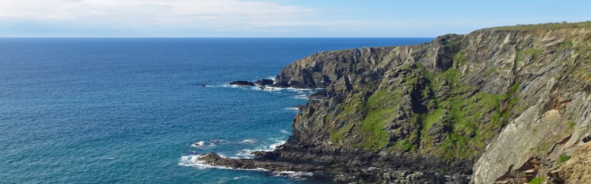
An introduction to the Wales Coast Path
In May 2012, the Wales Coast Path (WCP) officially opened, and since then, outdoor enthusiasts have been running and walking the coastline. As the longest waymarked trail in Britain, the route certainly poses challenges, but it is also a journey of interest, variety and constant change. Here is everything you need to know about the Wales Coast Path:

Walking the Wales Coast Path
Llwybr Arfordir Cymru
£17.95
A single guidebook to walking the whole Wales Coast Path - 1400km (870 miles) the length of Wales from Chester to Chepstow, including Anglesey, described in 57 stages. The route passes through the Snowdonia and Pembrokeshire National Parks and many AONBs and can be linked with the Offa's Dyke Path for a complete circuit of Wales.
More informationGet 10% off ALL of our walking guidebooks in Wales with the code WALES10 at checkout. Offer ends 30th April 2025!

How long is the Wales Coast Path?
The Wales Coast Path is Britain's longest waymarked trail at 1400km (870 miles), beginning in the north at Chester and following the coastline to Chepstow in the south.
How many days does it take to walk?
To walk the entire WCP takes around 2 - 3 months. The guidebook splits the route into 57 stages ranging between 16 and 32km (10 and 20 miles); however, additional time for rest days, shorter daily distances and exploring the local area should be accounted for when planning.
How difficult is the route?
The route is mostly easy to walk; however, there are infrequent rugged sections and short, steep ascents and descents. It is well waymarked with a seashell with a dragons tail as the route symbol.
How to get to the start?
If arriving by air, Liverpool John Lennon Airport and Manchester are the closest airports, and they are connected by train to Chester. Both Chester and Chepstow are well connected to the rest of the UK by rail, and this is the most convenient way to travel to and from the WCP.
Can you just walk a section?
Many transport options throughout the Wales Coast Path allow walkers to tackle the path in one- to two-week sections, covering a series of trips. Every single day's walk along the route is served by public transport, but frequency varies.
When is the best time to walk?
Summer is the best time to walk, and April to October will usually provide good weather, long days, and all services and facilities will be open. In September, things may be a little quieter. Walking on into autumn and winter is a possibility but, shorter days, wetter weather and some service closures may affect progress.
What about accommodation?
Accommodation is available at the end of each day, but the quantity varies from place to place. Options range between luxury hotels, B&Bs, hostels and campsites. For those walking on a budget, a combination of camping and hostels may be required as hostels are mainly concentrated in Pembrokeshire.
Wales Coast Path: Stage Summary
| Stage | Locations | Distance |
|---|---|---|
| 1 | Chester to Flint | 20.5km |
| 2 | Flint to Prestatyn | 29km |
| 3 | Prestatyn to Colwyn Bay | 23km |
| 3 | Colwyn Bay to Conwy | 23.5km |
| 5 | Conwy to Bangor | 30km |
| 6 | Bangor to Glan yr Afon | 24km |
| 7 | Glan yr Afon to City Dulas | 25.5km |
| 8 | City Dulas to Cemaes | 25.5km |
| 9 | Cemaes to Llanfachraeth | 30km |
| 10 | Llanfachraeth to South Stack | 22km |
| 11 | South Stack to Fourmilebridge | 23.5km |
| 12 | Fourmilebridge to Aberffraw | 22km |
| 13 | Aberffraw to Dwyran | 22.5km |
| 14 | Dwyran to Menai Bridge | 20km |
| 15 | Menai Bridge to Dinas Dinlle | 28.5km |
| 16 | Dinas Dinlle to Nefyn | 29km |
| 17 | Nefyn to Methlem | 26km |
| 18 | Methlem to Rhiw | 23.5km |
| 19 | Rhiw to Abersoch | 24.5km |
| 20 | Abersoch to Llanystumdwy | 28.5km |
| 21 | Llanystumdwy to Penrhyndeudraeth | 21.5km |
| 22 | Penrhyndeudraeth to Llandanwg | 17km |
| 23 | Llandanwg to Barmouth | 22km |
| 24 | Barmouth to Tywyn | 26km |
| 25 | Tywyn to Machynlleth | 26.5km |
| 26 | Machynlleth to Borth | 23.5km |
| 27 | Borth to Llanrhystud | 26km |
| 28 | Llanrhystud to New Quay | 22.5km |
| 29 | New Quay to Aberporth | 21.5km |
| 30 | Aberporth to St Dogmaels | 21.5km |
| 31 | St Dogmaels to Newport | 24.5km |
| 32 | Newport to Goodwick | 21.5km |
| 33 | Goodwick to Abercastle | 25km |
| 34 | Abercastle to St Justinian | 25km |
| 35 | St Justinian to Newgale | 24km |
| 36 | Newgale to Martin’s Haven | 27km |
| 37 | Martin’s Haven to Sandy Haven | 25.5km |
| 38 | Sandy Haven to Pembroke | 26km |
| 39 | Pembroke to Freshwater West | 32km |
| 40 | Freshwater West to Freshwater East | 24.5km |
| 41 | Freshwater East to Saundersfoot | 25.5km |
| 42 | Saundersfoot to Laugharne | 22.5km |
| 43 | Laugharne to Llansteffan | 24.5km |
| 44 | Llansteffan to Ferryside | 28km |
| 45 | Ferryside to Burry Port | 25km |
| 46 | Burry Port to Pen-clawdd | 25.5km |
| 47 | Pen-clawdd to Rhossili | 30km |
| 48 | Rhossili to Penmaen | 24.5km |
| 49 | Penmaen to Swansea | 24km |
| 50 | Swansea to Margam | 23km |
| 51 | Margam to Ogmore | 25.5km |
| 52 | Ogmore to Limpert Bay | 25km |
| 53 | Limpert Bay to Cadoxton | 21km |
| 54 | Cadoxton to Pengam Green | 24.5km |
| 55 | Pengam Green to Newport | 21km |
| 56 | Newport to Rogiet | 28.5km |
| 57 | Rogiet to Chepstow | 16km |
Route Extension
For an additional challenge, why not combine the route with the Offa's Dyke Path to complete the entire circuit of Wales.

Offa's Dyke Path
National Trail following the English-Welsh Border
£17.95
This guidebook describes Offa's Dyke Path National Trail, a 177 mile (283km) long-distance walk along the English-Welsh border between Sedbury (near Chepstow) and Prestatyn. The guidebook is split into 12 stages with suggestions for planning alternative itineraries. With OS 1:25,000 map booklet.
More information


